Investigating Participatory Mapping as a Tool for Engaging Communities in Planning for Relocation of Spent Nuclear Fuel Sites Subject to Climate and Coastal Hazards
This research will explore host community and expert viewpoints and attitudes about the prospective relocation of spent nuclear fuel away from California sites exposed to coastal and climate hazards. The project will examine how such viewpoints can be used to determine locations for alternative spent fuel storage sites. The Humboldt Bay Independent Spent Fuel Storage Installation (HB ISFSI) will be used as a test case for this research, as it is a site that is at risk from sea level rise, erosion, bluff inundation, tsunamis, and earthquakes. Despite these risks, the California Coastal Commission permitted the HB ISFSI in perpetuity, as currently no offsite alternative locations exist to store the spent nuclear fuel, and there is considerable uncertainty as to when alternative locations for fuel storage might become available.
Project Objectives:
(1) Determine which factors local community members in the Humboldt Bay area and other experts consider important when deciding whether and where to relocate the spent nuclear fuel stored at the HB ISFSI
(2) determine potential alternative locations to the HB ISFSI should the fuel need to be relocated within California to mitigate for coastal and climate risks and hazards.
Our Research:
A mixed methods approach will be used to meet the research objectives. This approach will involve conducting surveys and semi-structured interviews to identify the key factors that community members and experts consider important when determining suitable locations for storing spent nuclear fuel. Multiple-criteria decision-making (MCDM) will be used to determine the most effective way to prioritize these factors. Additionally, geographic information systems (GIS) will be used to perform site selection analysis and map potential sites for spent fuel storage within California. Surveys will then be used to evaluate whether these mapped locations align with the criteria identified by the community and experts.
This research may help identify conditions under which the existing California Coastal Commission permit licensing the HB ISFSI in perpetuity could be amended with special conditions acknowledging the climate and coastal hazard risk to the Humboldt Bay site. Additionally, it facilitates ongoing investigations into how existing and new policies and regulations governing nuclear power plant decommissioning and spent nuclear fuel licensing can be applied or amended to ensure meaningful engagement of host communities in long-term management decisions. This includes decisions to protect the fuel in place and potentially relocate it. This project relates to the wider Hub mission as it explores what steps could be taken to mitigate the effects of natural hazards on coastal communities by engaging host communities directly in research examining scenarios including managing and potentially removing critical infrastructure that may be affected by such hazards.

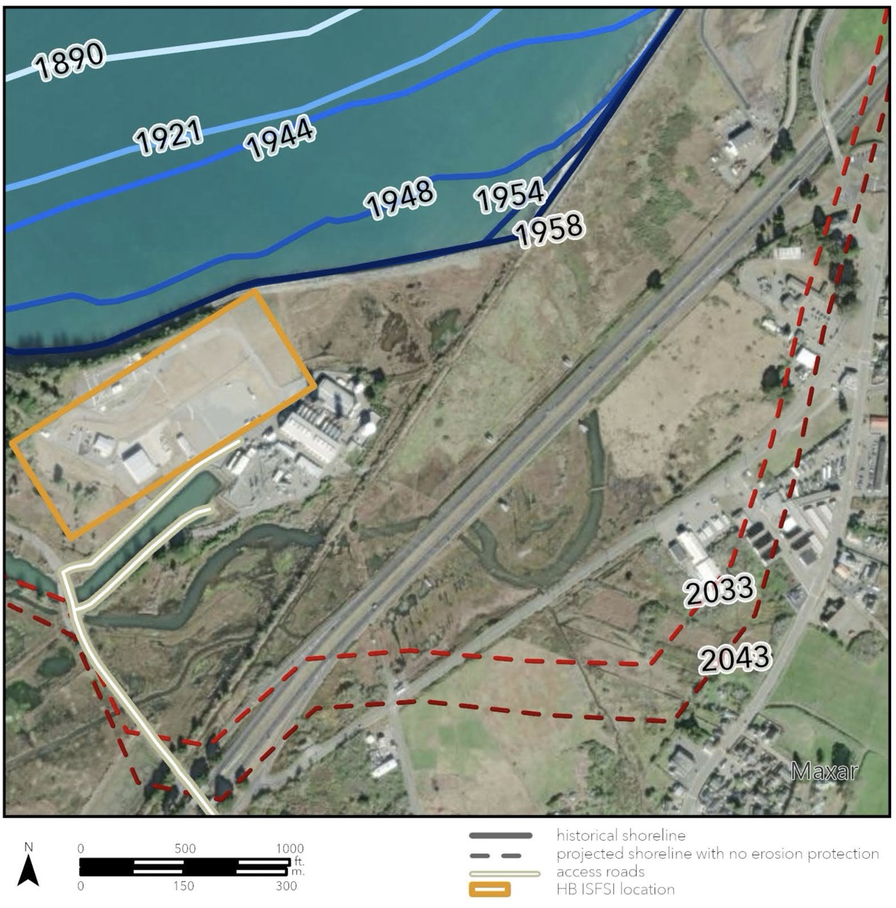
Historic Shoreline Retreat and Projected Retreat on Humboldt Bay if Protective Infrastructure is Compromised (Sorfleet, 2023). Projected shorelines were generated using the USGS Digital Shoreline Analysis System (DSAS) v5 software from historical digital shorelines retrieved from the Laird (2007) Humboldt Bay and Eel River Historical Atlas.

Media
Learn more at 44feetproject.com

