Stochastic Chronic Coastal Hazards Modeling
Chronic coastal hazards, such as flooding and erosion, are becoming more frequent and intense due to climate change. Many Cascadia communities are already beginning to feel the effects of elevated sea levels and changing storminess patterns on the coast. To effectively and equitably adapt to these changes, we need a comprehensive understanding of future hazards and the uncertainties associated with them. In the Stochastic Chronic Coastal Hazards Modeling Project, we use a range of modeling techniques to address knowledge gaps around Cascadia’s chronic coastal hazard drivers and exposure.

Project Objective:
To produce quantitative results and tools that provide a comprehensive understanding of future climate change-driven coastal hazards and their uncertainty across the Cascadia Region.
In this project, we use a combination of statistical, hybrid statistical-dynamical, and reduced-physics models to perform hazard exposure assessments, project shoreline change, and explore the impacts of future flooding and erosion hazards on communities in the region. The co-developed research described below is designed to advance our understanding of climate change impacts on coastal hazards as well as inform climate-change adaptation in Cascadia communities.
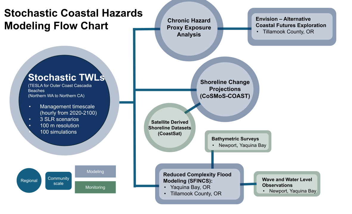
To improve the skill of these models, this project uses data obtained by several coastal monitoring endeavors, including the Cascadia-wide extraction of satellite derived shorelines and bathymetric surveys. We strive to make the results of this project relevant and accessible to Cascadia partners and have presented the results in many different formats to several different audiences.
This project uses hazard proxies for erosion, flooding, and unsafe beach conditions under three sea level rise scenarios (Leung et al., in revision) to identify areas within Cascadia that experience high hazard impacts and high rates of hazard change. These projections rely on simple calculations that can offer a first-cut assessment of where further research or greater investment in adaptation resources is needed.
This project uses a reduced-physics shoreline change model, CoSMoS-COAST (Vitousek et al., 2023), which focuses on probabilistic quantification of the location, intensity, and rate of coastal erosion, as well as changing beach widths induced by climate change until 2100 along the Cascadia coast. The CoSMoS-COAST model is calibrated by using the spatially and temporally high-resolution historical shoreline position data set (1984-2024) that is derived from publicly-available satellite imagery.
This project simulates compound coastal flooding in Yaquina Bay with highly accurate results and minimal computational demand using a reduced-physics flooding model, SFINCS (Leijnse et al., 2021). Yaquina Bay experiences flooding due to complex and compounding drivers, including waves, water levels, and precipitation. Using SFINCS to simulate a large range of future flooding scenarios allows us to quantify and assess flood hazard exposure and uncertainty at high resolution for the Yaquina Bay community.
Summary of major projects conducted by the Stochastic Chronic Coastal Modeling Team through the support of the Cascadia CoPes Hub.
Peer-reviewed articles:
progress:
Leung, M., Cagigal, L., Mendez, F., & Ruggiero, P., (2023). Projecting Future Chronic Coastal Hazard Impacts, Hotspots, and Uncertainty at Regional Scale. Preprint. Earth and Space Science Open Archive (In revision with Earth’s Future).
https://doi.org/10.22541/essoar.169722116.61393621/v1
Graffin, M., Kaminsky, G., Leung, M., Ruggiero, P., Taherkhani, M., & Vitousek, S. (2023). Monitoring interdecadal coastal change along dissipative beaches via satellite imagery at regional scale. Cambridge Prisms: Coastal Futures, 1, e42, Article e42.
https://doi.org/10.1017/cft.2023.30
Taherkhani, M., Leung, M., Ruggiero, P., Vitousek, S., & Allan, J. (2023). Multiscale assessment of shoreline evolution in the US Pacific Northwest via a process-based model. In Coastal Sediments 2023: The Proceedings of the Coastal Sediments 2023 (pp. 1437-1451).
- Regional Stochastic TWL modeling (TESLA) – Complete
- Regional Chronic Hazard Exposure Analysis – Complete
- Regional Shoreline Change Assessment – Mid Project
- Yaquina Bay Flood Modeling – Beginning