The Influence of Sediment Transport and Channel Change in Nooksack River Flooding
The Nooksack River in northwestern Washington State experiences flooding every couple of years and has a history of large floods that have caused extensive damage to local communities. Predictions that climate change will intensify large storms further motivate the need to understand and mitigate the impacts of these large flood events. This is the focus of a large group of managers, engineers, scientists and stakeholders in Whatcom County and British Columbia.

Project Objective:
Our research focuses specifically on the influence of sediment transport and associated changes in the conveyance capacity of the river channel on flooding.
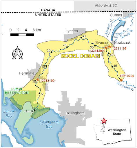
Figure 1
Map of the Nooksack River in northwestern Washington State. The domain of the numerical model is shown in yellow and cities and towns are marked in gray. The blue arrow indicates the route that the 2021 flood took north toward B.C.
Understanding history:
The Nooksack River in northwestern Washington State experiences flooding every couple of years and has a history of large floods that have caused extensive damage in Everson, Ferndale and Sumas. During a massive flood in November 2021, the river overtopped it’s banks near Everson carrying floodwaters north through Sumas and into British Columbia where it caused billions of dollars of damage.
Our Research:
Our research focuses specifically on the influence of sediment transport and associated changes in the conveyance capacity of the river channel on flooding. The supply of sediment to the Nooksack from the flanks of Mt. Baker is unusually high; relative to its discharge the Nooksack carries a sediment load that is more than twice as high as any other river in the Puget Sound region. As a result, the riverbed is very mobile and large floods can re-work and reconfigure the channel. The feedback between the river flow and the riverbed is complex. In some locations it may enlarge the channel, reducing overbank flooding. In others it may reduce the channel’s conveyance capacity and increase flooding.
We use a high resolution hydrodynamic and morphodynamic model to understand the feedback between channel change and flooding (Figure 1). The model resolves the two-dimensional, depth-averaged currents in the channel and floodplain with a nominal grid size of approximately 20m in the channel. It also computes sediment transport rates and uses those to determine how the bed elevation increases or decreases, resulting in changes to channel conveyance.