Cascadia Landslides and Consequences
To reduce community risk and increase community resilience, we must understand the impacts of earthquakes, storms, and seasonal precipitation on the generation and aftermath of landslides across Cascadia. Our goal is to comprehend when and why landslides occurred in the past. This knowledge will help us predict future landslides to reduce community risk and increase resilience. With this goal in mind, our landslide work is divided into three major objectives.

Project Objectives
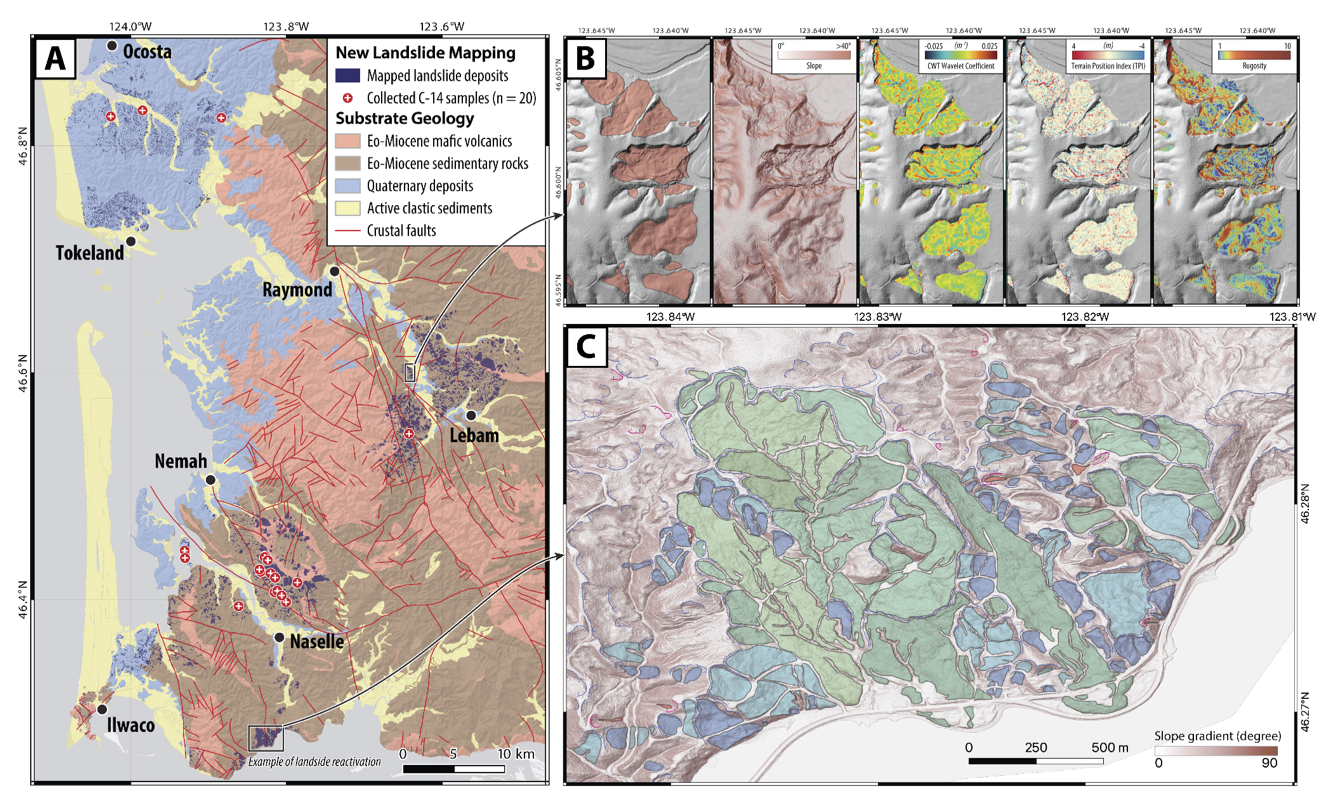
This project focuses on understanding the spatio-temporal distribution and natural controls of the deep-seated landslides in the coastal mountains of southwestern Washington, and seeks their possible association with other major historical geohazards such as large earthquake shaking and heavy rainfall events. Techniques applied in this research include mapping on the high-resolution digital elevation model and satellite images, radiocarbon dating and morphological analysis on the landslide deposits, field geomechanical measurements on the bedrocks, and geospatial statistics. The results will help reconstruct the historical landslide frequency and pattern, providing insights to and landslide susceptibility in northern Cascade.
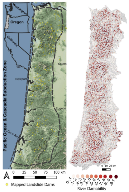
One project in this objective focuses on landslide dam susceptibility along Oregon Coast Range rivers. Landslide dams pose a unique threat due to their potential to lead to more hazard through catastrophic outburst floods. We implement a novel landslide dam susceptibility algorithm calibrated with landslides from the Oregon coast range to create a regional map of where landslide dams may be most likely to occur.
We are also developing a simulation based methodology to estimate recovery times of transportation networks that are disrupted by landslides. Such disruptions can cut off access to coastal communities, and their speedy recovery using limited resources is of utmost importance. These results can enable the identification of communities along the coast that are particularly vulnerable to islanding in the aftermath of CSZ, which results in multiple landslides, thereby contributing to Team 3’s goals of identifying differential community impacts and developing strategies for their mitigation.
An additional project seeks to model the impacts of co-seismic landslides. This research task focuses on modeling the susceptibility of earthquake-induced or “co-seismic” landslides using an updated version of the Multimodal regional-scale landslide simulation model (MM) and estimating the impact of landslides on communities, people, and infrastructure. The results of this project will contribute to understanding the spatial distribution of landslide exposure and vulnerability, aligning with Team 3’s goals in developing strategies for landslide mitigation.
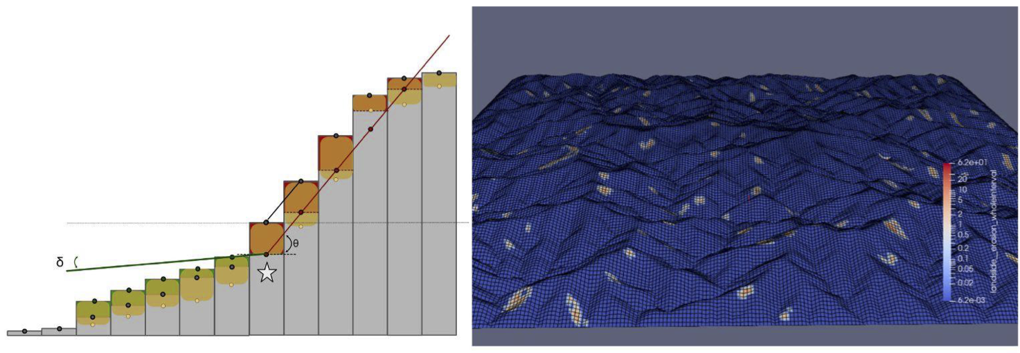
In this project we develop models to simulate landscapes with landslides. With these models we can test how landslides triggered by storms or earthquakes may continue to change the landscape, from the rivers to the ridges, long after they have slid.
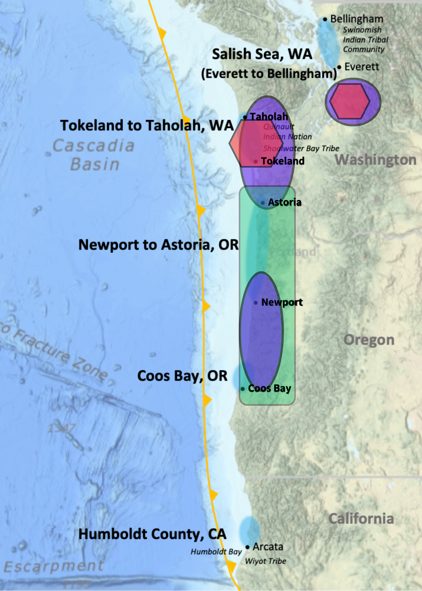
Project Locations
1) Mapping and dating of existing landslides to better understand drivers of mass wasting and hazards = mid project
2) Modeling to consider landslides and landslide dam hazards and their impacts on communities = mid project
3) Studying landslides in the context of longer term landscape evolution = beginning stages
Peer-reviewed articles:
Conference presentations:
Evidence of Seattle Fault Earthquakes from Patterns in Deep‐Seated Landslides. (2023) Erich Herzig*, Alison Duvall*, Adam Booth, Ian Stone, Erin Wirth*, Sean LaHusen, Joseph Wartman*, alex grant*
https://doi.org/10.1785/0120230079
Complex landslide patterns explained by local intra-unit variability of stratigraphy and structure: Case study in the Tyee Formation, Oregon, USA. (2023) Sean LaHusen and alex grant*
https://doi.org/10.1016/j.enggeo.2023.107387
Strong shaking from past Cascadia Subduction Zone earthquakes encoded in coastal landforms. (in review) Sean LaHusen & Alex Grant*, Jonathan Perkins, and Devin McPhillips
*hub members
Lai, L.S.-H., Duvall, A.R., Booth, A.M., Wartman, J., Grant, A., and LaHusen, S. (2023) Preliminary mapping of deep-seated landslides in the Washington Coast Range, Cascadia Subduction Zone. Abstract (EP23D-1963) presented at 2023 AGU Fall Meeting, San Francisco, CA, 11-15 December.
Herzig, E., Duvall, A.R., Booth, A.M., Stone, I., Wirth, E., LaHusen, S., Wartman, J., and Grant, A. (2023) Landslides induced by a Seattle Fault Earthquake, WA, USA. Abstract (S431-0436) presented at 2023 AGU Fall Meeting, San Francisco, CA, 11-15 December
Morgan, P., Duvall, A.R., Struble, W., LaHusen, S., Grant, A. and Wartman, J. (2022) Estimating landslide dam susceptibility along Oregon Coast Range rivers. Abstract (NH25D-0470) presented at 2022 AGU Fall Meeting, Chicago, IL, 12-16 December.